 ar
ar bg
bg hr
hr cs
cs da
da nl
nl fi
fi fr
fr de
de el
el hi
hi it
it ko
ko no
no pl
pl pt
pt ro
ro ru
ru es
es sv
sv tl
tl iw
iw id
id lv
lv lt
lt sr
sr sk
sk sl
sl uk
uk vi
vi et
et hu
hu th
th tr
tr fa
fa ms
ms hy
hy ka
ka ur
ur bn
bn mn
mn ta
ta kk
kk uz
uz ku
ku
Integrated Inclinometer
The JMZX-7100L sliding inclinometer is a field profiling instrument within the Kingmach Integrated Inclinometer group. It is used for measuring horizontal displacement changes inside soil masses in dams, building foundations, embankment slopes, underground construction projects, geotechnical slopes, and port engineering. The instrument combines a sliding inclinometer probe with a 3D-MEMS silicon capacitor biaxial inclinometer sensor and an integrated testing instrument. It supports mobile phone APP reading, Bluetooth transmission, large storage capacity for millions of readings, data download for numerical and graphical analysis, real-time wireless network sending, Chinese and English menus, and dedicated post-processing software. Published specifications include +/-90 degrees sensor range, 500 mm guide wheel spacing reference, a probe size of 26 mm by 776 mm, 8.5 kg total weight, 2 kg probe weight, -20 degrees Celsius to +60 degrees Celsius operation, 180 m water pressure impermeability, and 100 g vibration resistance.
Application of Integrated Inclinometer
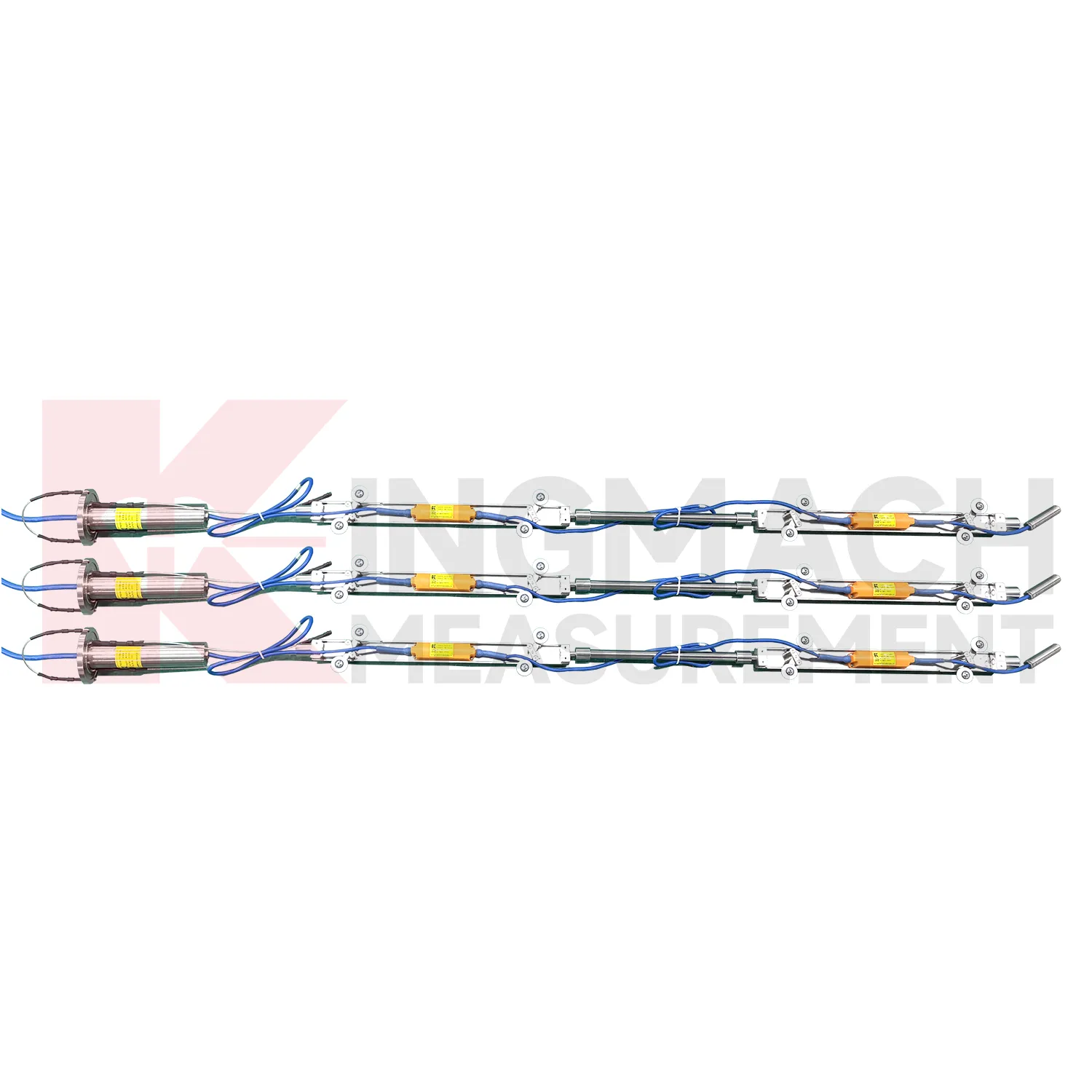
Slope and geological hazard monitoring use Integrated Inclinometer to detect internal movement before the surface condition becomes clear. JMQJ-7915ATS is especially relevant because its multi-point in-place inclinometer string can observe deformation at different depths inside a borehole. JMZX-7100L can also be used for sliding inclinometer profiling in geotechnical slopes, dams, embankment slopes, and port engineering. Slope tilt or inclinometer data should be read with rainfall, groundwater, crack width, surface displacement, retaining structure movement, and construction disturbance. The key question is often depth: is the movement shallow, deep, or concentrated along one weak layer? A borehole profile with consistent point naming and stable orientation gives engineers better evidence for warning, inspection, and stabilization planning.
The future of Integrated Inclinometer
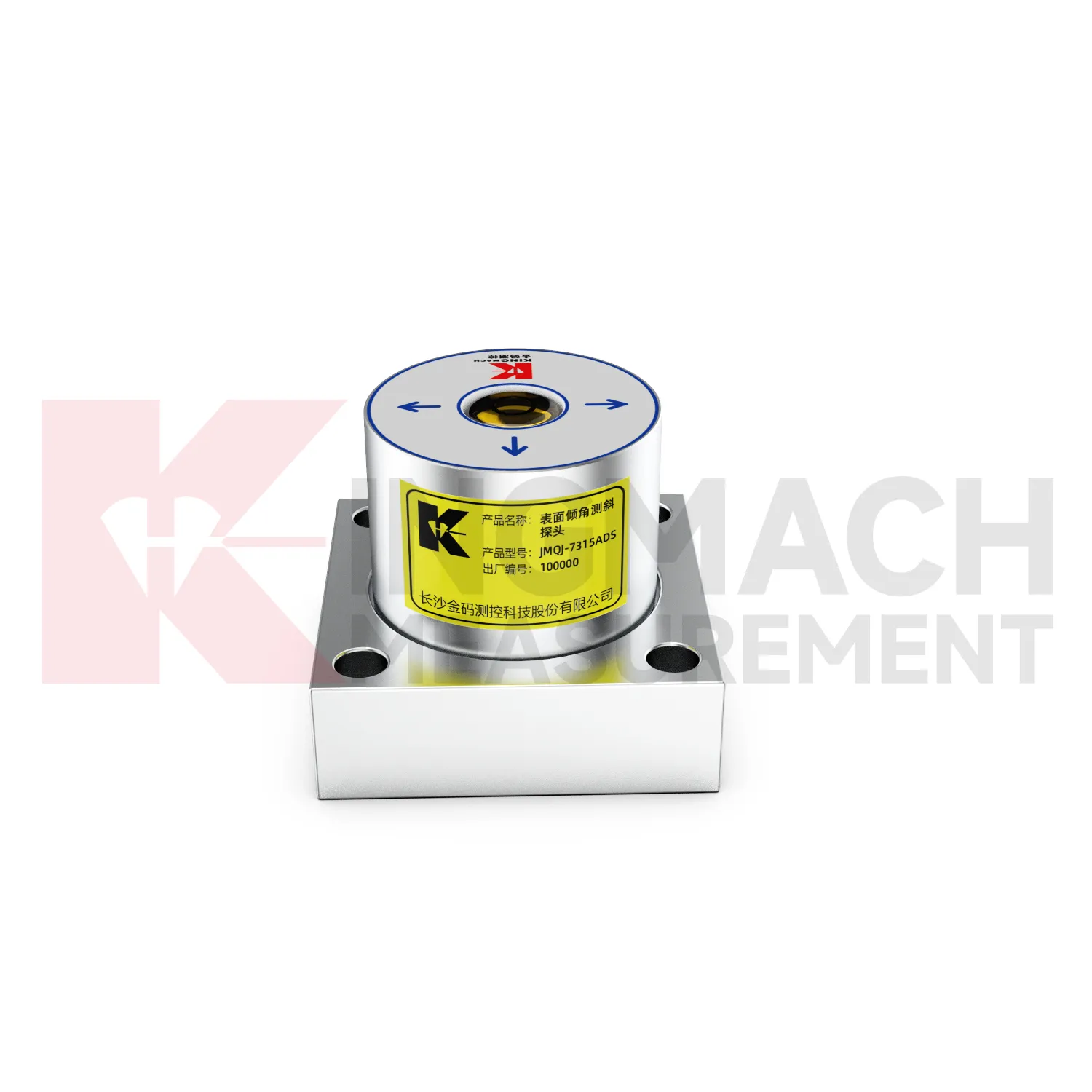
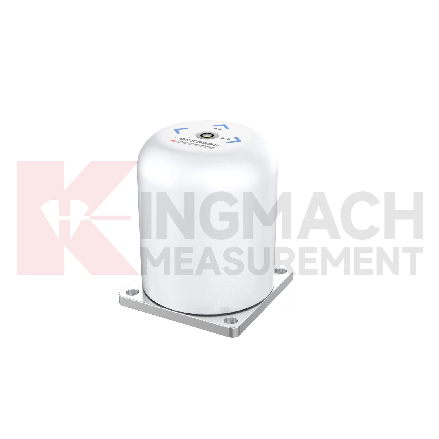
The future of Integrated Inclinometer will include stronger links to maintenance budgeting. Owners of bridges, railways, dams, tunnels, buildings, slopes, and towers need to rank which assets are stable and which require inspection or repair. Long-term tilt records can support that ranking when they are collected consistently and tied to structural locations. JMQJ-7315ADS, JMQJ-7315RTU, JMQJ-7915ATS, JMZX-7100L, and JMZX-4QH provide different paths for collecting angular or internal deformation data. Future asset systems can connect these records to inspection cycles, repair dates, weather events, and risk categories. The result is a tilt record that supports planning, not only construction-stage warnings.
Care & Maintenance of Integrated Inclinometer
Baseline maintenance for Integrated Inclinometer should be treated as a controlled record. The first value should be taken after the sensor, bracket, borehole string, or casing has stabilized. Do not reset a baseline silently when a curve looks inconvenient. If the point is moved, recalibrated, repaired, or replaced, keep the old value, new value, date, reason, technician, and related photographs. For in-place inclinometer systems, record depth position and group communication information. For sliding inclinometer work, keep the casing reference and reading direction consistent. A visible baseline history makes long-term tilt data easier to defend during review, especially when monitoring extends across construction stages and ownership handover.
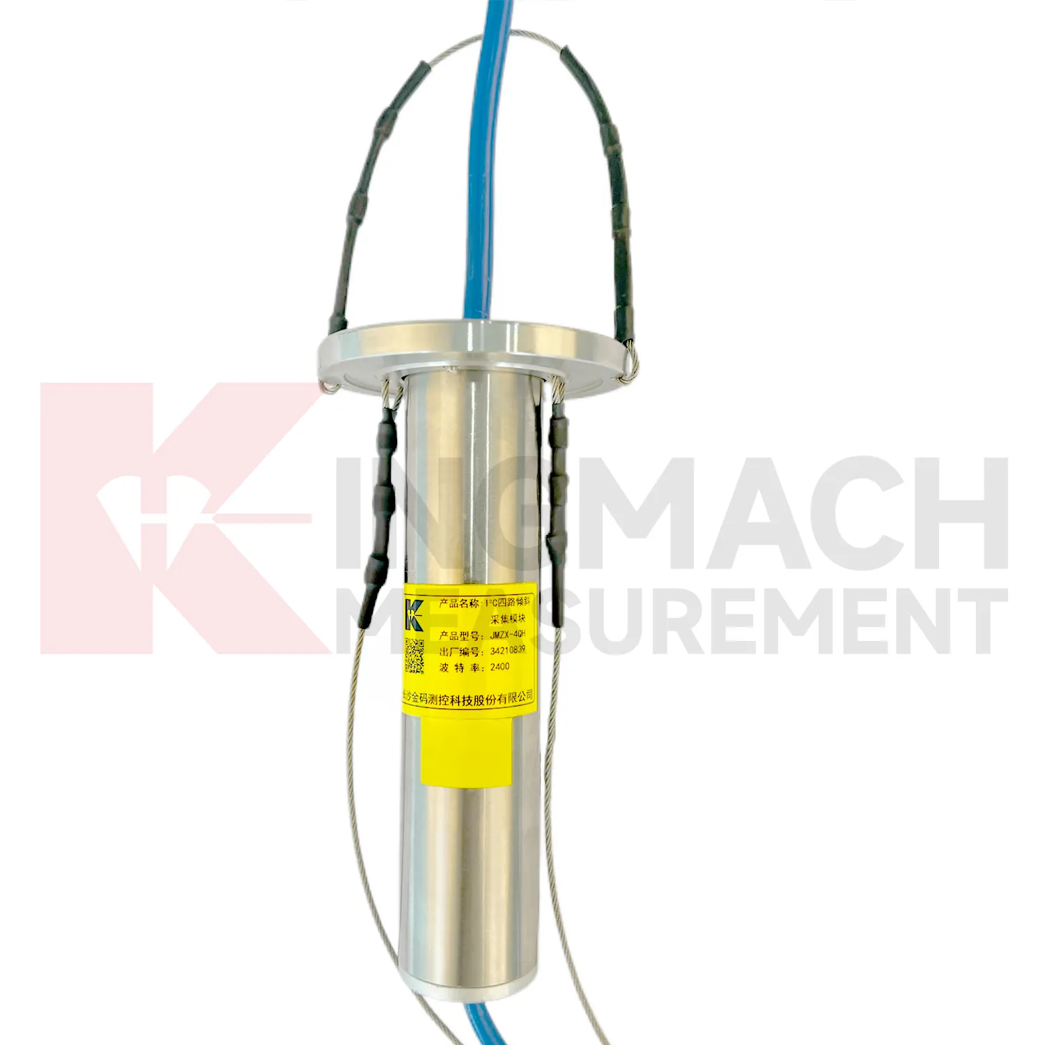
Kingmach Integrated Inclinometer
For procurement teams, Kingmach Integrated Inclinometer are not one single instrument type. The product group includes JMQJ-7315ADS fixed tilt sensors, JMQJ-7315RTU integrated wireless tilt units, JMQJ-7915ATS vertical in-place inclinometer systems, JMZX-7100L sliding inclinometers, and JMZX-4QH inclination acquisition modules. Each serves a different monitoring method. A fixed tiltmeter follows one structural point. A wireless integrated unit reduces site wiring. A vertical in-place system reads multiple depths in a borehole. A sliding inclinometer supports field profiling inside inclinometer casing. An acquisition module collects many downhole sensors through grouped communication. A good purchase record should match range, accuracy, communication mode, protection grade, power supply, installation method, and site access. That makes the instrument package easier to install, verify, and maintain after delivery.
FAQ
Q: How should Integrated Inclinometer be installed?
A: The mounting surface or borehole position should be stable, the axis direction must be recorded, and the baseline should be saved after the instrument settles.Q: Why is axis direction important?
A: Tilt values only have engineering meaning when the positive and negative directions are tied to the structure, slope, tunnel, or borehole drawing.Q: Can these instruments work in wet sites?
A: Several Kingmach models list IP65, IP67, or IP68 protection, but glands, connectors, cabinets, and cable entries still need field inspection.Q: What should be checked during commissioning?
A: Check model, range, serial number, communication, power, baseline, point name, mounting photo, channel address, and related site condition.Q: Can a tiltmeter be reset after installation?
A: It can be re-baselined when necessary, but the old value, new value, reason, date, and technician should remain visible in the record.
Reviews
Matthew Garcia
Instrumentation cables are durable and perform well even in harsh environments. Will definitely order again.
Michael Anderson
The strain gauges and load cells are extremely accurate and stable. They performed very well in our bridge monitoring project. Highly recommended!
Latest Inquiries
To protect the privacy of our buyers, only public service email domains like Gmail, Yahoo, and MSN will be displayed. Additionally, only a limited portion of the inquiry content will be shown.
Olivia***@gmail.comUnited States
Hello, we are currently sourcing high-precision strain gauges and load cells for a bridge monitoring...
Emma***@gmail.comCanada
Dear Sir/Madam, we are interested in displacement transducers and settlement sensors for a geotechni...